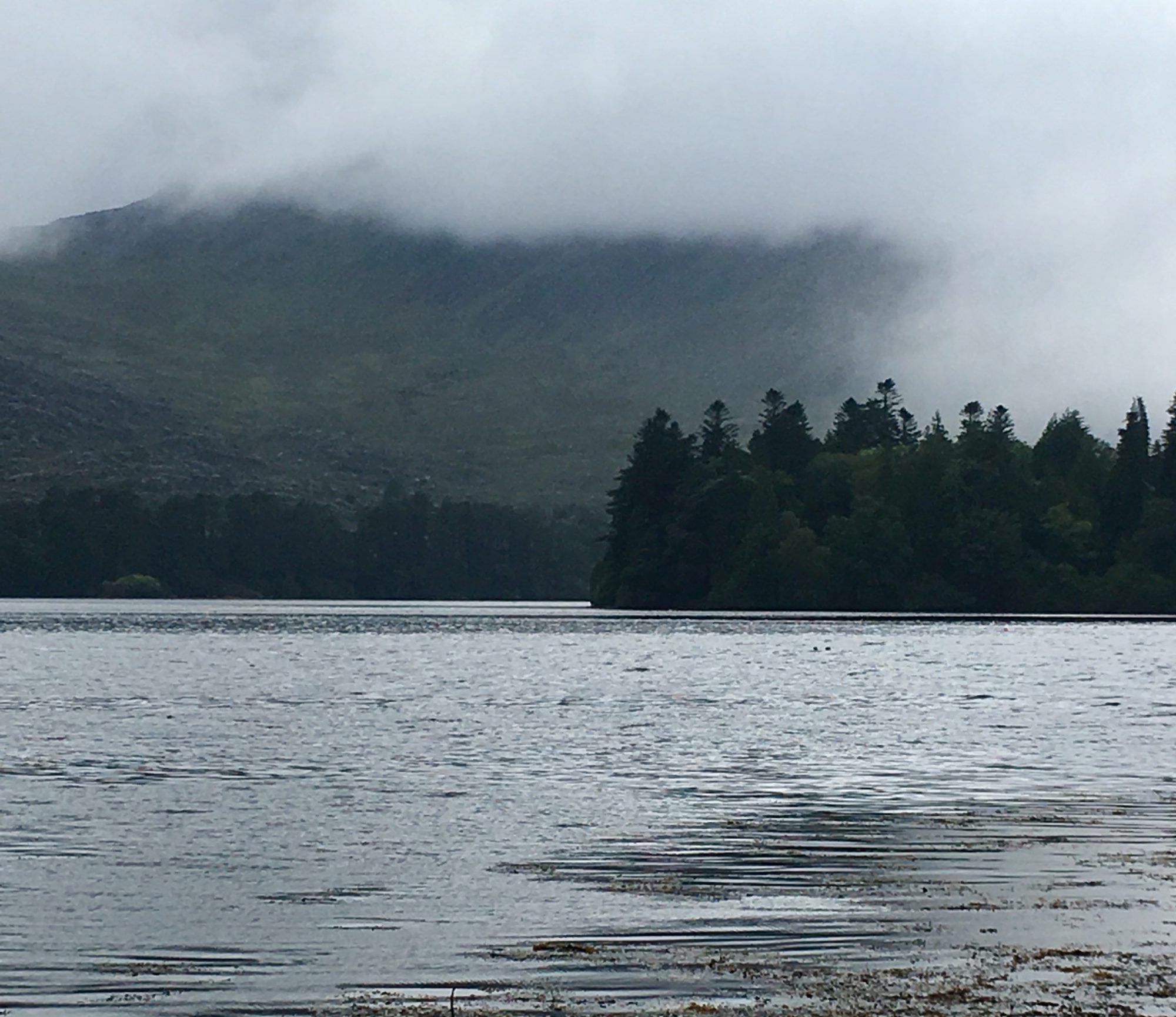
Knoxville is gray and cool today, but not cold and snowy like what we flew away from. Sam lives in North Knoxville now, a neighborhood that straddles a hill between First and Second Creeks. The streets are lined with historic houses in Folk Victorian, Queen Anne, Eastlake and Craftsman Bungalow styles, front porches set up to be three season rooms, with homes at every level of repair and restoration and dilapidation represented. It’s an interesting area for walking, and a far departure from our usual few miles down Canterbury Road and into the woods at home.
Though this certainly isn’t a tropical beach relaxation retreat, this is a vacation, even if mini. We’re away from our ordinary routines, which opens up the days to exploration and enjoyment of the neighborhood, the fantastically-serious-about-it-all-and-getting-it-just-right K Brew coffee shop two blocks away, our books, my poetry, David’s sketching and painting, studying maps to find hikes and then hiking, yoga with a teacher who can transition from downward dog to easy seated pose by jumping and swinging her legs under her body and through her arms as she crosses her ankles in front before lowering to her sitz bones, and downtown lights glittering last night across the river from Sam’s friend’s condo on a bluff.
Now muted sunlight is making shadows on the hardwood floors of the apartment. Time for another walk.
Don’t go looking for 1 – 17. I’m starting with 18 because that’s the day’s date, the date of the day I caught on to this year’s Mindful Writing Challenge.
I drove home from Albany today, across southern Vermont, just ahead of the snow that was moving up the Hudson Valley, smack into the snow off the coast. Again and again as I drove Rte. 7 and then Rte. 9, the horizon would be pulled up close with the steep slope of a field, the curve of the hill climbing to sky. Like skiing up from the bottom of the hay field behind the Johnson’s old farmhouse, a field of snow bleeding off into blue. I love that view.
Intentions are a means of getting ourselves where we want to be, rather than letting life’s currents spin us along. Not that letting currents take you into unknown and unexpected territory is a bad thing. After all, my tag line for this blog is “Life is more about floating down river than it is marching across a field.”
Balance is the key, between letting events and experiences unfold, and making sure you have enough of what sustains you in your life. The intention David and I committed to for this year — to get above tree line at least once a month — was meant to make sure we have enough hiking in our lives, because hiking to a view is nourishing for both of us. The effort, the exercise, often the friends with us on the hikes, the reliable renewal of being outdoors, and the visual expanse all contribute to the pleasure we get from being above tree line.
So does the hiking we did in Arizona and Utah count towards that intention? Yes. Even though we weren’t technically getting above tree line, we were hiking. A lot. In fact, in the Grand Canyon we hiked down to an elevation that would be far above tree line in New Hampshire, and for the entire time we were out west we were at elevations that would be above tree line here. We had expansive views on every hike, mostly because we were below tree line, we were outside for most of every day, and there was plenty of effort and exercise, often to get to a mesa top where there were trees again, after walking through rock-walled canyons.
We had the intention of going out west to center our days around being outdoors, walking in new territory, and seeing vastly different landscapes. And that’s what happened. It was grand.
David and I arrived in Santa Fe on Saturday night, after a drive through Southern Colorado that we both found stunning and comforting at the same time. Land more like home, hillsides colored with vegetation rather than layers of rock, open valleys with horses and cows, and the southern end of the Rockies making a jagged ridge of the far horizon. We came here with the intention of spending time with Marsie, experiencing the delights of this city, and being civil and obedient. In other words, relaxing. We’ve achieved all those goals.
After four days in Santa Fe I now understand why people are smitten with this city. The russet and cashew-colored adobe buildings, with their low profiles, soft rounded edges and decorative wooden doors are soothing to walk among. The coyote fences made from rows of standing sticks are unlike anything at home, able to last in the dry air under perpetually sunny skies. The people are friendly and talkative and everyone has a story of how they came to be in Santa Fe. There is art on every corner, in a gallery or a courtyard or the central plaza. Mountains define the horizons, whether up close or distant, and there is a network of trails throughout the city, including the 5 mile trail we hiked yesterday that took us to the top of Atalaya Mountain, a 1,500 foot climb to look over Santa Fe below. And the food is simply fabulous. We’ve had a couple of meals here that compare to anything we’ve had anywhere.
But it’s more than all these things by themselves. There’s a slower vibe here, an appreciation for beauty and the sensual delights of a hospitable climate and stunning natural world. The colors are vibrant and striking and subtle at the same time, with sage brush spreading across red earth, interspersed with the deep green of pinyon pine and juniper. In the mountains ponderosa pine hold their broad needle fans up into the sky to contrast their sun-sheened green with the deep blue. It makes me feel relaxed, and that’s no small thing for me.
We fly back to New Hampshire today. It’s been a grand trip and we’re already planning the next western adventure. In the meantime, David is busy organizing a NationalParksProtest movement, so check out his blog Old Man Bad Back. Want to take back our national parks and make a statement about the government shutdown? This is your chance.
Just as we were rounding the first mound of rock to disappear on the Chimney Rock Trail in Capital Reef National Park yesterday, we heard a siren whirl from the road and saw a National Park truck pulling up to the trailhead. We’d parked in a pull-out up the road and walked down to the trail. The word in town (because we’d talked to people as we bought groceries and coffee) was that all the trail entrances along Route 24 were blocked, people were parking elsewhere and walking to the trails, and if they got caught, were being given $150 tickets. David and I stopped and looked and a woman got out of the truck and yelled at us. “You need to come back and get off this trail.”
We walked back. The ranger began the conversation by being firm and telling us we had to leave, that it didn’t matter to her if we felt we weren’t doing anything wrong by walking on our public land, and that we’d get ticketed (yes, $150) and even arrested if we didn’t get off the trail.
“But we were in the park yesterday,” I said. We’d gone to the southern end of Capital Reef the day before, because we’d heard (everyone out here is talking about the national park closures) at dinner that the eastern and southern ends of the park were open. “They only have 5 rangers for the whole park,” one person told us. “They can’t patrol it all.”
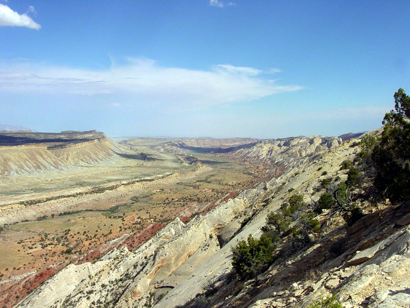
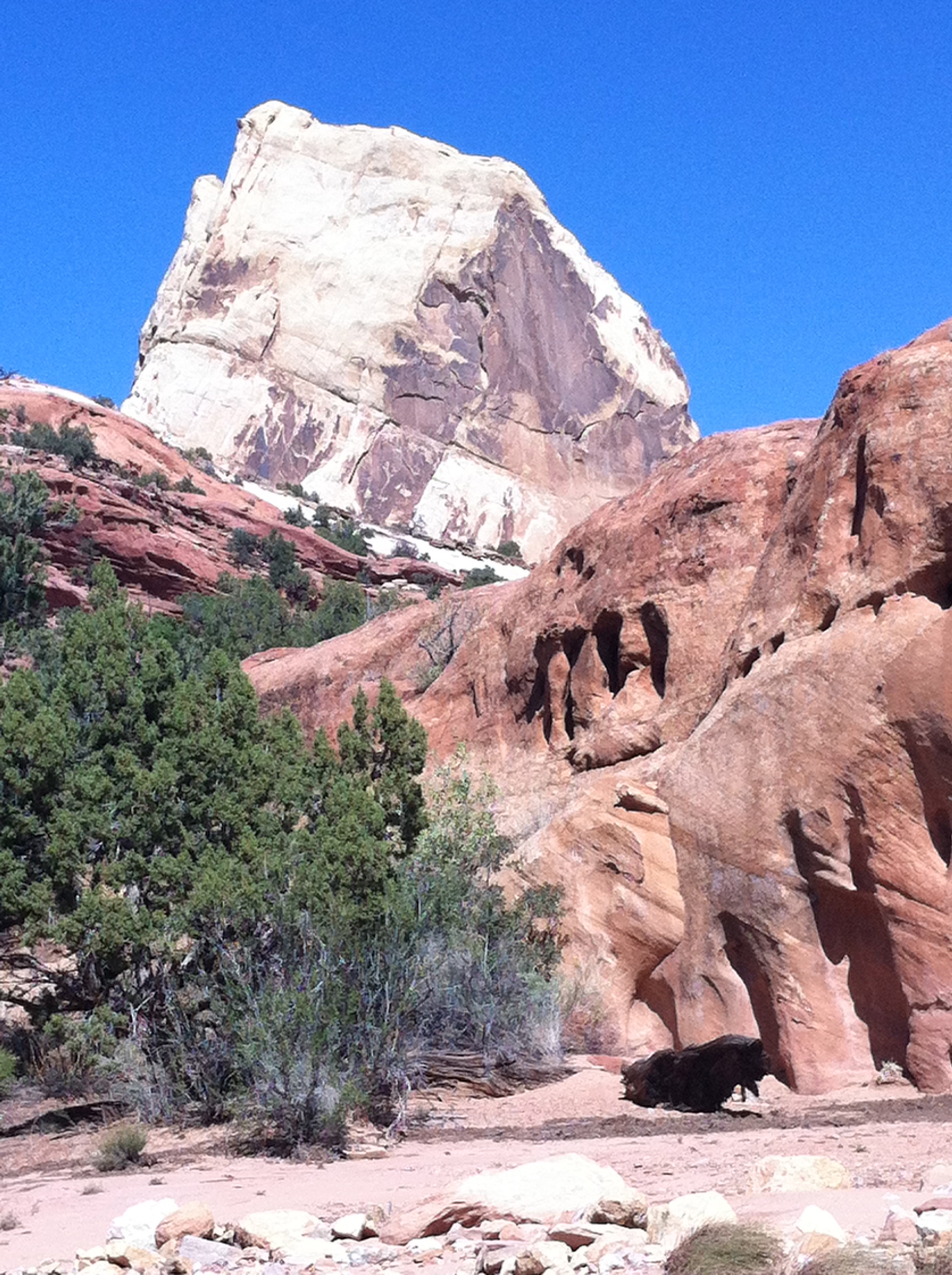
We’d driven the long, gravel Notom Road down the eastern side of the park, then turned on the Burr Trail, a 35 mile road that climbs through the Waterpocket Fold of Capital Reef on steep and narrow switchbacks. The fold is an upheaval of layers of the earth along a fault that’s almost 100 miles long and that reaches over 2500 feet (it used to reach over 7,000 feet). David and I had hiked the Upper Muley Twist Canyon the day before, which follows the wash of a river through the spine of the fold after climbing to the top, providing incredible views of the jumbled rocks stretching north and south.
Photo from Wikipedia
“We were on the Upper Muley Twist trail yesterday,” I told the ranger. “Well you were hiking illegally,” she said. We hadn’t really engaged in civil disobedience, I thought but didn’t say, because there were no signs saying the trail was closed. Instead, I told the ranger I felt a moral obligation to continue to hike as planned, in spite of the national park closures, because I truly believe the parks are public land and that the public can’t be denied access. David talked to her about his vision of national park protests and sit-ins by older Americans, the people taking back the parks. “You’d need to pick a more well-known park than this one,” she said. She argued with us for a few more minutes, but then started suggesting other hikes that wouldn’t be illegal and asked us not to continue with our protest right then and there by continuing to hike, “because then I’ll have to arrest you and take you to jail all the way in St. George, and that’s not going to be fun for anyone.”
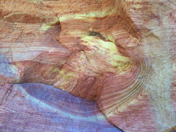
The ranger was reasonable, she was only doing her job (without pay), she was listening to us and she was nice. We didn’t want to ruin her day, and we didn’t want to spend the weekend in jail (which the ranger had told us would likely happen if she did arrest us) so we left, after thanking her for working without pay. We drove back down the Notom Road to Cottonwood Wash, another river bed that runs west into the Waterpocket Fold, and walked up through a series of unimaginably varied, colorful and angled rocks.
We’d shifted our plans and decided to do half of the long drive back to Santa Fe yesterday, rather than a 10 hour drive today, so we came to Durango, Colorado last night. We’d heard it’s a wonderful town (it is) and the drive was spectacular, with the widely varying landscapes we’ve come to expect on this trip, including a long descent through a red canyon, 1,000 foot walls of Navajo sandstone rising on either side of us, and dropping us at a northern edge of Lake Powell where the Dirty Devil and Colorado Rivers flow in. Towards the end of the drive we got into more familiar looking mountains, forested with spruce and colored russet and golden with the changing foliage of oaks.
We expected an interesting and charming town, steeped in cowboy culture, which we found. What we didn’t expect is that this weekend is the 25th anniversary Durango Cowboy Poetry Gathering. Last night after dinner we walked into the Strater Hotel and listened to cowboy poets reading and singing and telling stories. All the men were wearing cowboy hats and all the poems rhymed.
The next four days in Santa Fe don’t include plans to visit national parks, so our days of civil disobedience might be over. Or maybe we’ll get back to New Hampshire and start organizing in a park people have heard of. A sit-in at Acadia next weekend?
“I’m not talking to you anymore,” the man ranger said to David, holding his hands up as if to push David away. We’d stopped to get out and talk to the rangers when we saw two of them standing in front of orange cones and making cars turn around on the road into Bryce Canyon National Park. I was having better luck talking to the woman ranger.
“Would I be breaking a federal law or a regulation if I drive down the road and park?” I asked her and she said she wasn’t sure, but then decided it was a federal law. “You’ll be arrested,” she said. “We have national park law enforcement and they’ll arrest you and take you to jail.” By then David had joined the conversation, since the man ranger wouldn’t talk to him any more.
“I’m in a place in my life where that might be okay,” David said. “What jail would they take us to?” David and I told the ranger about our idea of organizing thousands of vacationing grandparents and getting them to stage a sit-in at a national park lodge and refuse to move. I told her about my history of civil disobedience, having been arrested at the Seabrook nuclear power plant and at a Wall Street protest in the 70’s. She told us she was working without pay, “because I love this park.” We told her we’d created a Twitter hashtag #nationalparksprotest but since I only have about 80 Twitter followers and David just set up a Twitter account last night to tweet under that hashtag it probably wasn’t going to get a lot of traction. She laughed.
David and I thanked both rangers for working without pay, then got in the car and drove down a dirt road we found out of the parking area across the street. We found crowds of people on the rim of the canyon, most of them having taken a back road behind the Bryce Canyon Best Western, some in tour buses. We crossed the fence into the park and started walking, following foot paths along the edge of the canyon. The further we walked the more spectacular the hoodoos (the spires of rock that make Bryce so remarkable) became. The rocks got redder and the canyon glowed with color.
At a mile and a half we reached the first parking area of the park and picked up the official park trails. We kept going until we reached Sunrise Point, an elevated platform which looks out over the Bryce Amphitheater. We were the only ones there. The only people we met actually in the park (most people who’d come in the back road to the rim weren’t going more than a few hundred yards) were Europeans. I welcomed them to our national park and they smiled and thanked me.
Tomorrow, Capital Reef National Park, which is vast and criss-crossed with back roads. We’ll find a place to park and take another hike on our public land.
David and I were already planning to hike the East Rim Trail in Zion National Park today. The trail head is only a few miles down the road from where we’re staying, just inside the east entrance to the park, and we were looking for a less crowded area to hike. We also knew the government was probably going to shut down and we figured this would be an easier place to access the park. We knew we’d get past the entrance, because Utah State Route 9 runs through the park.
At the entrance the ranger in the booth told us the park was closed, that we could only drive through on Rte. 9 and couldn’t stop anywhere on the road. So we drove the 100 yards to the turn off for the trail head and pulled in. Just before the parking area, the gate was closed. I got out of the car, untied the yellow caution tape (Caution, Congress in Session?), opened the gate and David drove through. We parked and started our hike.
The trail was beautiful, less majestic than in Zion Canyon, but quiet and still full of an amazing variety of rock formations and views of cliffs and tree topped mesas. We only saw 6 other people during our morning hike — on most Zion trails you see 6 people in the first minute of the hike. A man and his son were sitting at the top of Jolly Gulch, looking down the canyon when we arrived.
“We’re practicing civil disobedience,” I said. “The parking area at the trailhead was gated, but we just opened the gate and came in.” The man nodded. “I had the same thought,” he said. He and his son had driven a back road to the boundary of the park, just behind the canyon and walked in. “This is a good place to be today.” Hiking back to the trial head we met two couples on the trail. They’d parked just outside the entrance of the park and walked in. They couldn’t go hiking from the park campground where they were staying, because they were told “you can’t recreate in the park.” They have to leave their campsite by tomorrow.
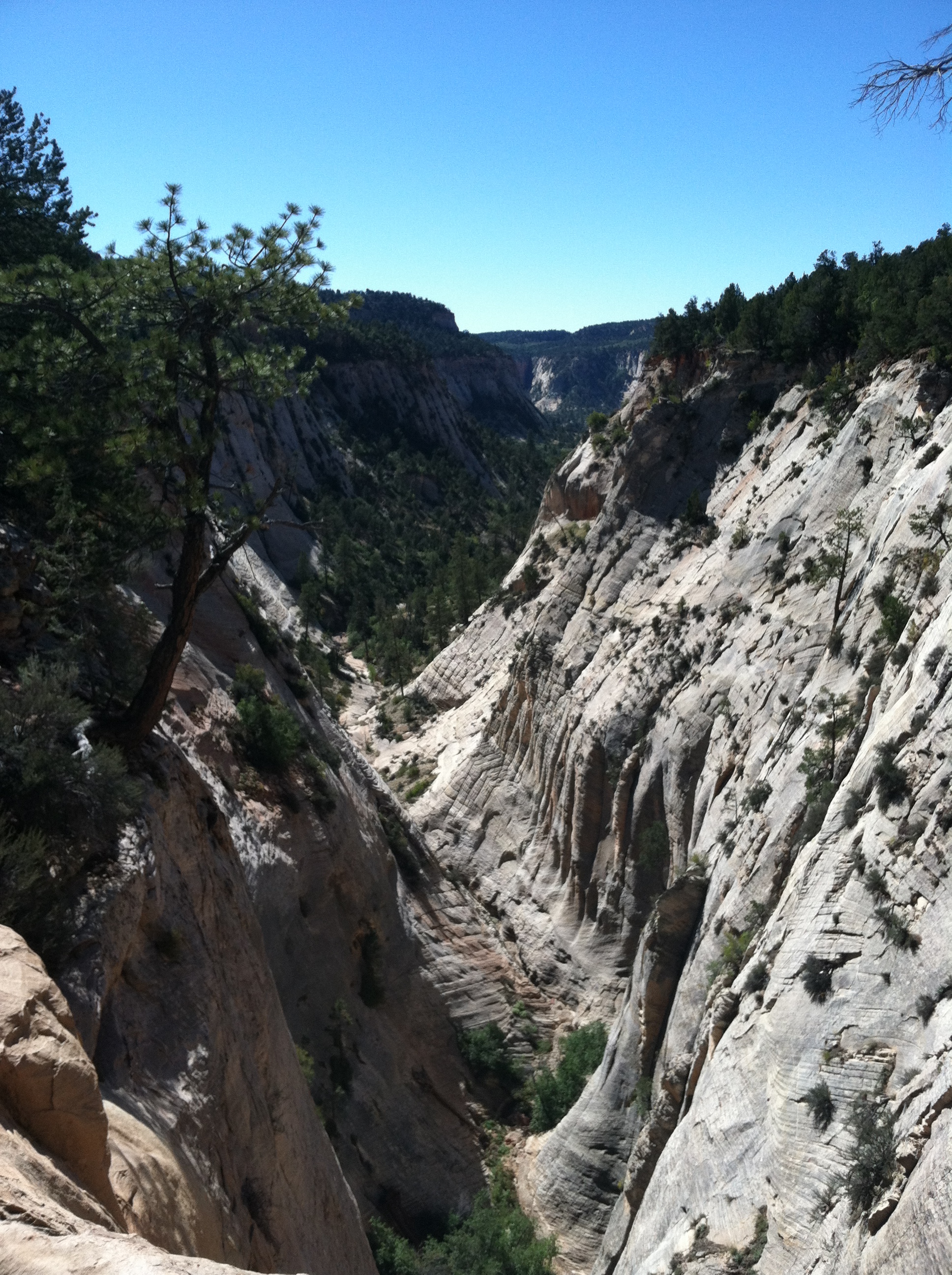
So today no one got to hike to Observation Point, which we did yesterday, unless they did a very, very long hike in from the East Rim Trail (another 7 miles from where we turned around today, then you’d have to come back). It was a grand hike, up through part of Echo Canyon, where the red sandstone has been washed into curves and ripples.
Following switchbacks up the cliff faces, we reached the top of the mesa and walked through scrub vegetation, out to a point with views down Zion Canyon.
Tomorrow we’re headed for Bryce Canyon National Park, and we’ve been studying topo maps to figure out how to get into the park and hike. And we will get into the park and hike. Woody Guthrie had it right.
This land is your land This land is my land From California to the New York island; From the red wood forest to the Gulf Stream waters This land was made for you and Me.
Steve Almond had an excellent article in The New York Times recently about Elizabeth Gilbert and her new novel. Gilbert talks about spending time with Julia Roberts before the London premiere of the movie based on her best-selling book Eat, Pray, Love. “It’s stupid how beautiful she is,” says Gilbert. “It’s like getting clubbed on an ice floe.”
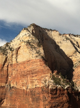
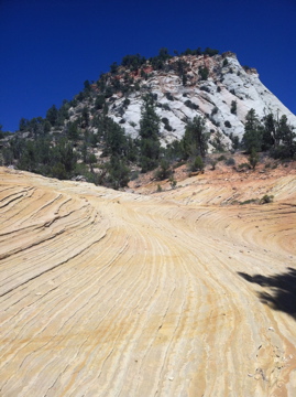
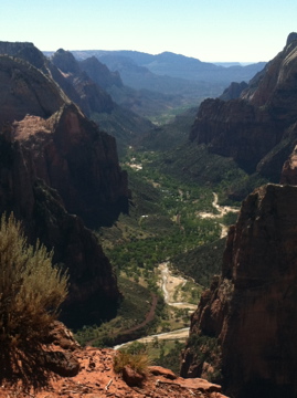
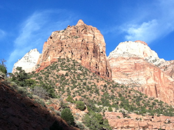
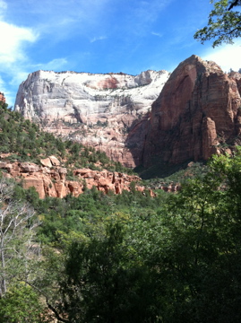
Zion National Park is that stupid and I’m feeling clubbed by beauty. “It’s majestical,” a young man said to me today at the head of Hidden Canyon and he was completely right. As you travel down Pine Creek Canyon coming into the main part of the park from the east, or ride up Zion Canyon, spires of light gray rock come into view from behind massive, sculpted towers of red sandstone, and then in the distance a white mesa topped with green pine draws a line across the horizon. David and I have seen a lot of spectacular in the last few days, but Zion National Park takes it to a whole other level.
Getting to Hidden Canyon was a triumph for me. Zion is known for having very steep drop offs along the edges of some hiking trails, and this was one. The trail description makes it clear that it’s not appropriate for people afraid of heights. That would be me to some extent, so we decided to do the trail and see just how afraid I was. At one point I had to sit down and think about whether I could keep going. A nice young couple was coming down the trail and assured me there were good chains to grab ahead. I grabbed and kept going. And made it. I was rewarded with incredible views. The photo below, with the chains hugging the rock wall to the right, is not by me. There was no way I was stopping to take out my phone and take a picture.
Tomorrow we’re going back to hike up to one of the highest spots in the park, Observation Point. Then we’re heading back down to hike The Narrows along the floor of the canyon. Not a trail, the Virgin River, with canyon walls reaching up thousands of feet on either side of us. This is a hike where getting your feet wet is part of the trip.
Yesterday David and I hiked to the level of Mt Washington, the highest point in NH. Only we hiked down to 6,200 feet, starting at 8,300. The North Kaibab trail makes its way into the Grand Canyon through switch backs and rock edged ledge trails, the variegated walls of the canyon showing the history of the earth’s crust as the trail descends. We climbed down through the white-stoned Kaibab formation into the Supai layer, colored with red limestone. As we descended through the layers of earth the dust on the trail changed from gray to rosy brown to red, mirroring the walls around us.
We met several people on the trail who were hiking rim to rim in a day – in as few as 6 hours in fact. We were more than satisfied with our 4 hour trek down into the canyon. The hiking is as easy as we’d hoped, with flat sandy footing, switchbacks to make the grade manageable and scenery galore.
Now we’re having our usual morning coffee on a deck. Today the deck is at the North Rim Lodge and we’re watching the sun light the walls of the canyon, layer by layer.
Yesterday’s drive across New Mexico into Northwestern Arizona was stunning. Mesas stretched straight lines across the horizon, with steep sides of white and red and variegated rocks. Mountains lifted spruce and sage up over the mesa tops into the clear sky. Wide open plateaus dotted with juniper and pinon spread out as far as we could see, climbed into forests of pine, then descended again to flat vistas with ridges of rocks in the distance. Hard wind drove across the wide spaces, picking up loose sand and whipping clouds of dust into the sky.
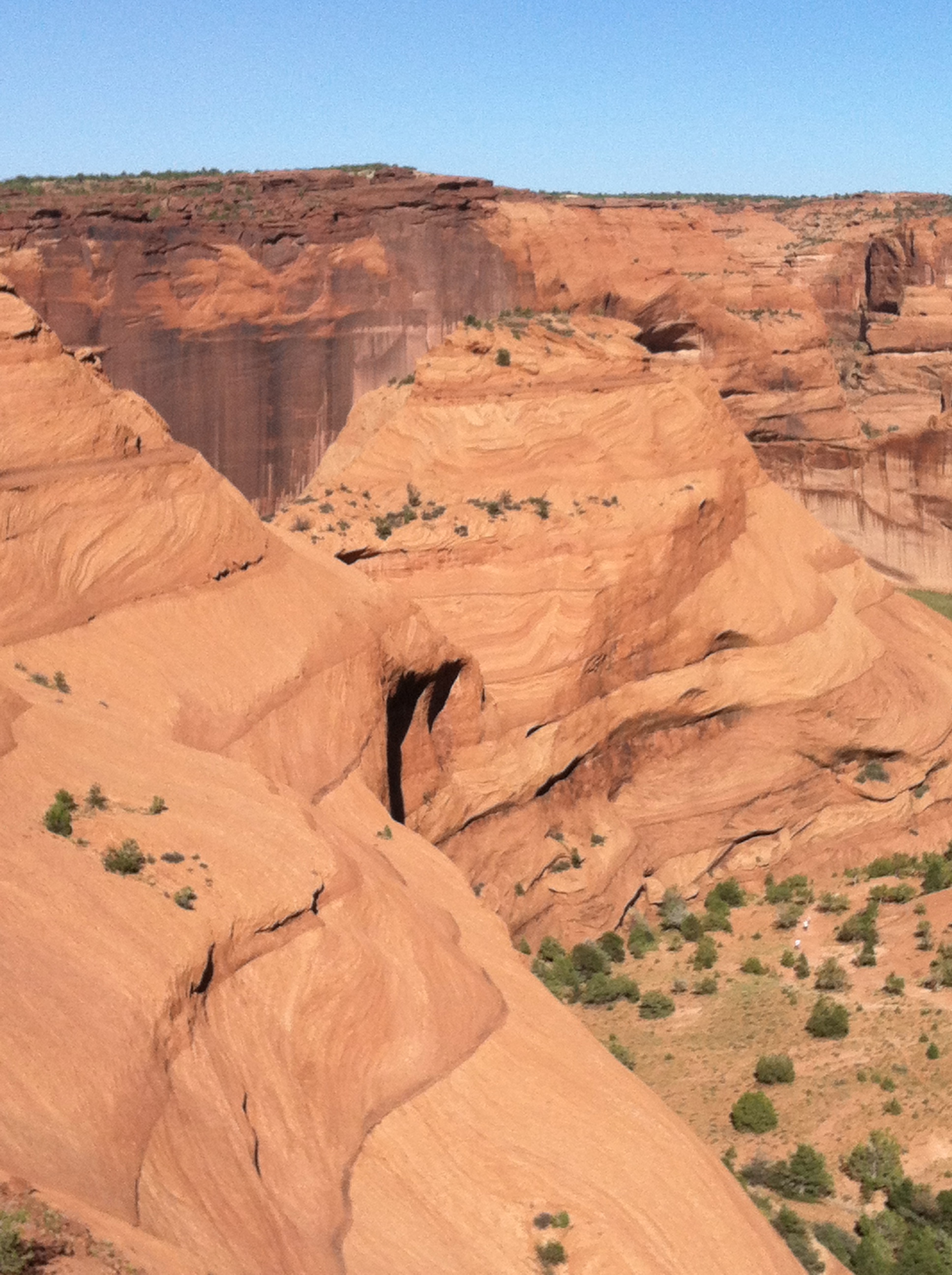
Then we arrived at Canyon de Chelly, a sacred space for the Navajo People. People have lived in the canyon for over 5,000 years, farming the soil of the canyon bottom and building homes in the alcoves of the canyon walls. Access to the floor of the canyon is restricted to one public trail or a trip into the miles and miles of canyon with a Navajo guide. We drove along the South Rim, stopping at overlooks, and hiked down the public trail to the White House ruins, the remains of cliff dwellings. More than stunning, almost more than we could take in.